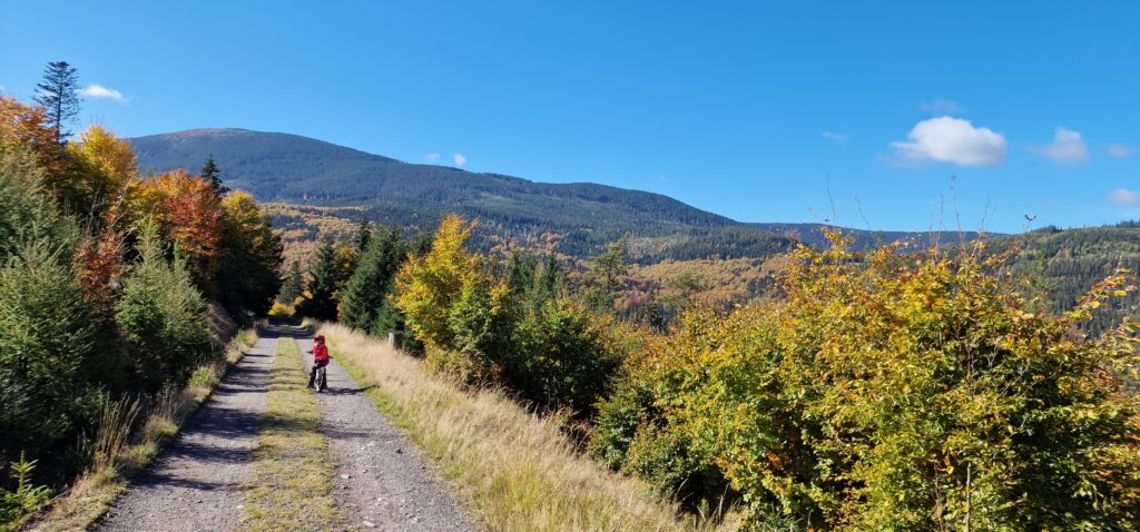
And now a paradise for cycling enthusiasts! And it doesn't matter if you're a mountain bike lover, enjoy the thrill of enduro, or simply want to spend quality time with your family surrounded by nature – over 380 km of cycling trails will provide everyone with joy.

SINGLETRACK GLACENSIS
Welcome to the Singletrack Glacensis, to make it easier to navigate the system, we have divided it by the towns through which the singletrack runs directly or nearby. We have designated access pointswhich are the places where you can park your car and start your ride. We have added difficulty scale to help you choose the best loop for you.
Our singletracks consist of 27 loops and one two-way section. Regardless of where you start your adventure, you will always return to the same place. The trails are marked with red and blue colors, and when you ride forward, you follow the same color, while changing color means turning back.
You can come to us for just one day and ride one or several loops, but Singletrack Glacensis is also, or even primarily, a unique mountain bike trail. It allows you to ride the entire circuit Kłodzko Land singletrack bike paths. The entire route from Srebrna Góra to Jagodna is approximately 260 km along with asphalt or gravel connectors. It's up to you to decide how many days such an expedition will take. Good luck and see you on the singletrack!

Near our Settlement, you can ride the loops of Rudka and Stronie Śląskie. Details are available in the link below :
"Singletrack" trails in the Śnieżnik Massif :
Trails - Singletrack Glacensis
BIKE PARK CZARNA GÓRA
It is the perfect place for every cyclist, both professionals and amateurs! It features 12 trails of varying difficulty levels as well as a Kids and Skills Arena.

SUPERFAST LUXTORPEDO TRAIN - You can ride the trails:
Skills Arena It includes trails for intermediate and advanced riders. It consists of 6 trails:
Municipal cycling trails
1 "To Lądek-Zdrój" (Stronie Śląskie → Strachocin → Stójków → Lądek-Zdrój, length: 6.3 km / travel time: 45 min)
1_do_ladkazdroj.gpx (47.39KB)
2 "Under Łysiec" (Stary Gierałtów → Goszów → Stary Gieratów, length: 14.90 km / travel time: 2 hours)
2_pod_lyscem.gpx (106.61KB)
3 "Gierałtowska Loop" (Stary Gierałtów → Karpno → Nowy Gierałtów → Stary Gieratów, distance: 11.8 km / travel time: 2 hours.),
3_petla_gieraltowska.gpx (85.84KB)
4 "Bialskie Mountains Loop - Eastern" (route: Stary Gierałtów → Nowy Gierałtów → Bielice → Przełęcz Sucha (1001 m) → Przełęcz Dział (922 m) → Stary Gieratów, distance: 25.20 km / travel time: 4 hours)
4_petla_gor_bialskichwsch.gpx (188.25KB)
5 "Bialskie Mountains Loop - Western" (route: Stronie Śląskie → Młynowiec → Przełęcz Dział (922 m) → Przełęcz Sucha (1001 m) → Nowa Morawa → Bolesławów → Stara Morawa → Stronie Śląskie, distance: 25.60 km / travel time: 4 hours)
5_petla_gor_bialskichzach.gpx (178.98KB)
6 "To the border crossing at the Płoszczyna Pass" ENTRANCE NEXT TO THE SETTLEMENT BEYOND THE MOUNTAINS BEYOND THE FORESTS (route: Bolesławów → Nowa Morawa → Przełęcz Płoszczyna (817 m) → Kamienica → Bolesławów, distance: 14.80 km / travel time: 2 hours)
6_na_przel_ploszczyna.gpx (104.12KB)
7 "Road over Lejami" ENTRANCE NEXT TO THE SETTLEMENT BEYOND THE MOUNTAINS BEYOND THE FORESTS
(route: Zalew w Starej Morawie → Stara Morawa → Kamienica → Droga nad Lejami (1010 m) → Kletno → Stara Morawa → Zalew w Starej Morawie, distance: 22.20 km / travel time: 4 hours)
7_droga_nad_lejami.gpx (158.66KB)
8 "Janowa Góra Loop" (route: Stronie Śląskie → Stronie Śląskie wieś → Janowa Góra → Kletno → Stara Morawa → Stronie Śląskie, distance: 15.60 km / travel time: 2 hours)
8_petla_janowej_gory.gpx (112.73KB)
9 "To the shelter "Na Śnieżniku" (route: Sienna, upper station of the cable car on Czarna Góra - Przełęcz Żmijowa Polana - Żmijowiec - PTTK mountain hut "Na Śnieżniku" - Kletno - Sienna, distance: 19.20 km / travel time: 3 hours)
9_na_snieznik.gpx (135.17KB)
Cycling Routes Czech Republic
1.Paprsek – Smrek – Forest bar – Horní Lipová – Ramzová – Petříkov – Paprsek
2. Staré Město – Návrší – Observation tower/Rozhledna Hynčice Pod Sušinou – Staré Město
3. Staré Město – Stříbrnice – Płoszczyna Pass /Kladské sedlo – Kunčická Hora – Paprsek – Staré Město
TRAIL PARK DOLNI MORAVA
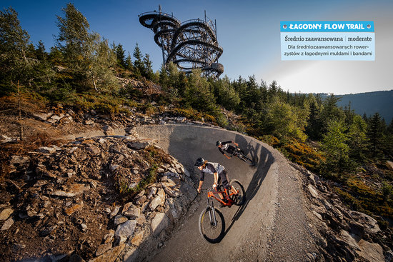
Second longest route suitable for less difficulty for intermediate riders of all generations. Safe flow trail route, not difficult in technical terms, with gentle moguls and bands, leads under the Path in the Clouds and on several sections it offers beautiful views of Chlum and the Lower Moravian valley.

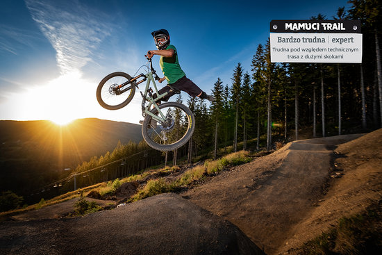
A technically challenging route for experienced cyclists who like to get off the ground. It has the steepest of routes very varied surface, full of waves, bands, wooden benches and contains a lot of technical faults.
Bicycle Guide
To get acquainted with the exact course of the trails, download our bicycle guide (2019 edition, "Compass" Kraków):
Polish-Czech version PL-CZ Stronie Śląskie guide.pdf (42.21MB)
English-German version ENG-DE Stronie Śląskie guide.pdf (42.32MB)